On 20 and 21 June 2023, Brittany’s offshore renewable energy (ORE) sector will be present at the Seanergy trade fair. At the Paris-Porte de Versailles exhibition centre, it will be flying the Bretagne Ocean Power banner. Alongside the Bretagne Pôle Naval cluster, the ports of Brest and Lorient and the Paimpol-Bréhat test site, 13 ORE technology companies will be present. Among them will be 4 suppliers of mapping and imaging technologies, reflecting the region’s expertise in these areas. Artificial intelligence, spectral imagery, electromagnetism and more will be on show, as we take a closer look at these aerial and maritime solution providers.
Imaging from the air
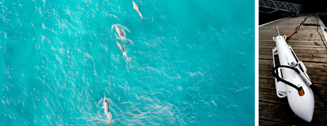
WIPSEA unveils the secrets of marine fauna thanks to AI
ChatGPT, Midjourney or Dall-E… These artificial intelligence solutions have been part of everyday language for some time now. But AI is not a new subject. Researchers have been working on it for several years now. Specialising in image analysis, the team of 5 employees that make up WIPSEA have been working on it since 2013, in collaboration with the Obelix team from IRISA at the Université Bretagne Sud, to carry out a digital census of marine megafauna from the air. “Artificial intelligence saves time and money,” says Gwénaël Duclos, CEO and founder of WIPSEA. The photos taken from the air are huge, on the order of 150 million pixels covering areas of 200m x 100m with a resolution of 1 to 2 cm per pixel. The aim is to make it possible for observers to analyse the thousands of photos acquired during a census by providing them with assistance. The AI tells them where to look and suggests a label for the species and behaviour”. The figures prove it: the AI analyses a photo in just 30 seconds. “We manage to produce maps after two months, once the experts have validated them.”
In partnership with Avion jaune, which takes charge of the aerial photography, and Cohabys, which maps the data collected by WIPSEA, the company is responding to calls for tender for offshore renewable energy projects under the PIXSEA umbrella. For example, it was involved in the construction of the Courseulles-sur-Mer and Fécamp wind farms, prior to work commencing. “Depending on where the site is to be located, the number of overflights changes, particularly when it is close to a offshore park. Wind farm developers overlay maps of wildlife, wind corridors and the seabed to find the most cost-effective location with the least environmental impact.”
Its WILDDRONE-PIXSEA drone was recently selected by the GIS EMYN collaborative research network linking organisations involved in offshore wind. “This project involves integrating our high-resolution aerial photography platform into a long-extension drone alongside the digital monitoring already ordered by the wind farm. The aim is to demonstrate that the drone, coupled with very high-resolution aerial imagery and artificial intelligence, can produce results comparable to those obtained by the digital aerial monitoring currently being carried out”. The comparison will be made during 4 flights over the course of a year.
Hytech-Imaging detects marine megafauna using spectral imaging
Brest-based Hytech-Imaging is developing the uses of spectral imaging for marine cartography. “Spectral imaging is a special kind of imaging that uses the full light spectrum for each pixel in an image, and not just the three main colours red, green and blue,” explains Marc Lennon, the company’s chairman and co-founder. For the development of offshore renewable energy projects, the company founded in 2016 uses a specially designed system. Called STORMM (système de télédétection optique d’aide au recensement de la mégafaune marine) and developed in collaboration with Pelagis, one of France’s leading observatories for marine mammals and birds, and France Énergies Marines, it carries four high-resolution imaging heads to meet the challenges of observing marine megafauna and avifauna. Thanks to its ability to capture images over a width of 400m, STORMM has travelled the seas of the west coast to help set up the future MRE sites at Courseulles-sur-Mer (AO1), Dieppe-Tréport (AO2), Centre-Manche (AO4) and Sud-Bretagne (AO5).
Hy-Tech Imaging is involved in the entire offshore wind farm project. From the preliminary studies carried out by the French government, in particular with the Migratlane programme studying bird migration routes, to the work carried out by private project developers. A drone version of the ‘Solar Stormm’, developed in collaboration with XSun, designers of a long-endurance solar-powered drone, will be on display at the fair.
Mapping from the sea
MAPPEM Geophysics uses electromagnetism for geology and obstacle detection
Founded near Brest by two doctors specialising in electromagnetism and electronics, MAPPEM Geophysics conducts campaigns to investigate the subsoil of the sea to study its geology or detect buried objects (rocks, mines, etc.).
The company helps its customers to improve their knowledge of the characteristics of the environment (porosity, proportion of sand, presence of gas, etc.) using an innovative method of imaging the resistivity of the subsoil. This technique helps prevent potential dangers associated with anchoring wind turbines or passing cables. MAPPEM Geophysics can also be involved in measuring electromagnetic noise to assess the impact of wind farms on the environment. “Depending on the project, we have developed different solutions. Before the project, we examine the ground to get an overview of the deep geology and we study the presence or absence of obstacles,” explains Andrew Weller, business development manager. We also carry out ambient electromagnetic measurements, which consist of taking a ground-zero survey of the pre-project area, and then carrying out further measurements after the wind farm has been installed to study its impact.”
With 6 employees, the company operates in France at the Saint-Nazaire and Fécamp sites, as well as at the Paimpol-Bréhat test site, and abroad at wind farms in the Netherlands.
Quiet-Oceans, the ears of offshore energies
Drawing on its knowledge of the military world, Quiet-Oceans, a company based in Brest, France, specialises in analysing underwater acoustics to measure their impact on biodiversity. Founded in 2010, the company is developing two types of product. Firstly, it is setting up a monitoring system with the installation of hydrophones to characterise the different sources of noise. To map these sources, its IT team is developing an underwater noise modelling solution. “Our platform is connected to oceanographic databases. It enables us to determine the conditions under which acoustic waves will propagate underwater, and it feeds into the knowledge of government departments and other sectors,” explains Carl Bois, the company’s sales director.
Quiet-Oceans applies its expertise to offshore wind farm projects to compare the impact of construction work on noise levels perceived at a site and on the number of species present. During construction of the field, its teams position buoys to measure noise levels and inform the operator in real time so that he can adapt and remain within environmental standards, i.e. around 160db for France.